# Player Builds # Creative 1.15 # New Page # Jatkosotan embassies in PCB This is a list of the **Jatkosotan embassies in PCB.** ### **PCBSSR** # Suriname
**Suriname** Jakobstad SSR
**District in an SSR**
[![surinamephotos1.jpg](https://portal-media.projectcitybuild.com/uploads/images/gallery/2024-06/scaled-1680-/tCAzA0Gj2nw4Nhu5-surinamephotos1.jpg)
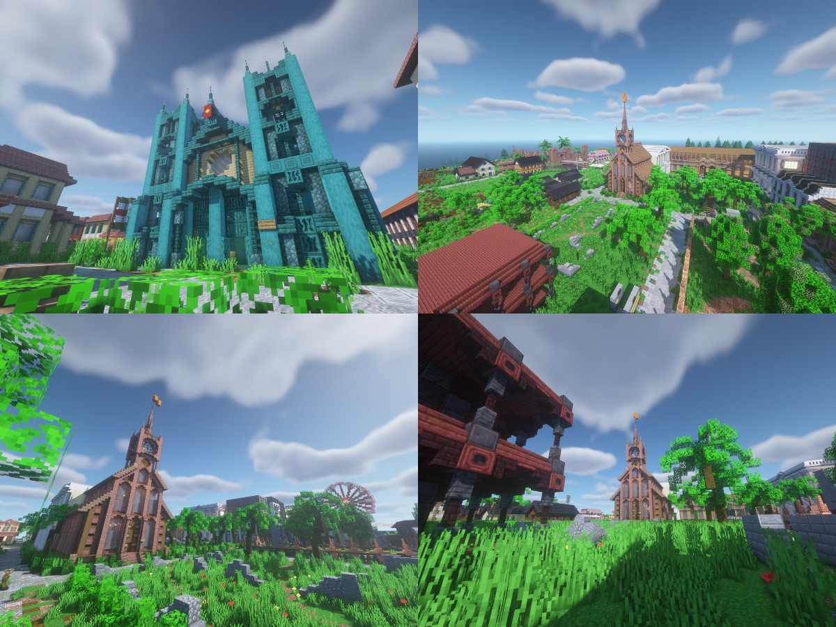
](https://portal-media.projectcitybuild.com/uploads/images/gallery/2024-06/tCAzA0Gj2nw4Nhu5-surinamephotos1.jpg) Sint-Petruskerk Overview of Suriname • Sint-Pauluskerk and the Anton de Kompark Sint-Pauluskerk and the old school
[![Flag_of_Suriname.jpeg](https://portal-media.projectcitybuild.com/uploads/images/gallery/2024-06/scaled-1680-/Gr6LIleZpJ47POVJ-flag-of-suriname.jpeg)](https://portal-media.projectcitybuild.com/uploads/images/gallery/2024-06/Gr6LIleZpJ47POVJ-flag-of-suriname.jpeg) Flag of Suriname ![Seal of Pjaia.png](https://portal-media.projectcitybuild.com/uploads/images/gallery/2023-08/scaled-1680-/DVIqNi7DH6CyLDnb-seal-of-pjaia.png) Seal of Pjaia
Motto(s): *Vrede, Gelijkheid, Gerechtigheid* ("Peace, Equality and Justice")
**Country: [![Ajudige Flag](https://portal-media.projectcitybuild.com/uploads/images/gallery/2023-08/scaled-1680-/V96wJv6GrhECPcSs-ajudige-flag.jpg)](https://portal-media.projectcitybuild.com/uploads/images/gallery/2023-08/V96wJv6GrhECPcSs-ajudige-flag.jpg)[ ](https://portal.projectcitybuild.com/books/nations-of-115/page/ajudige "Ajudige")**[Ajudige](https://portal.projectcitybuild.com/books/nations-of-115/page/ajudige "Ajudige") **Governate:** Kingdom of Ajudige
**Municipalities:** 6
**Demonym(s):** - Pjaiax (Formal) - Ajuarelaix (Colloquial) - Pjaian (English) - Paieño(-a) (Spanish)
**Climate:** Csb (Warm-Summer Mediterranean Climate)
**Timezone:** UTC-9 (SLST)
**HDI:** 0.905
**Suriname** # Pjaia --- #### **Overview**
**Cidadiu del'Pjaia** The City of Pjaia
**Capital City**
**[![Pjaia Wiki Page](https://portal-media.projectcitybuild.com/uploads/images/gallery/2023-08/scaled-1680-/HOTF8yDtfMF67xxs-pjaia-wiki-page-photo.jpg)](https://portal-media.projectcitybuild.com/uploads/images/gallery/2023-08/HOTF8yDtfMF67xxs-pjaia-wiki-page-photo.jpg)** Overview of Pjaia City Hall • Sunset on Basque Beach Ajudige Capital Building
**[![Pjaia Flag.jpg](https://portal-media.projectcitybuild.com/uploads/images/gallery/2023-08/scaled-1680-/SqlfDwU5CzJrYSH2-pjaia-flag.jpg)](https://portal-media.projectcitybuild.com/uploads/images/gallery/2023-08/SqlfDwU5CzJrYSH2-pjaia-flag.jpg)** Flag of Pjaia ![Seal of Pjaia.png](https://portal-media.projectcitybuild.com/uploads/images/gallery/2023-08/scaled-1680-/DVIqNi7DH6CyLDnb-seal-of-pjaia.png) Seal of Pjaia
**Nicknames:** - The Pearl of the Seas - The Mother City - City of Waves
**Country: [![Ajudige Flag](https://portal-media.projectcitybuild.com/uploads/images/gallery/2023-08/scaled-1680-/V96wJv6GrhECPcSs-ajudige-flag.jpg)](https://portal-media.projectcitybuild.com/uploads/images/gallery/2023-08/V96wJv6GrhECPcSs-ajudige-flag.jpg)[ ](https://portal.projectcitybuild.com/books/nations-of-115/page/ajudige "Ajudige")**[Ajudige](https://portal.projectcitybuild.com/books/nations-of-115/page/ajudige "Ajudige") **Governate:** Kingdom of Ajudige
**Municipalities:** 6
**Demonym(s):** - Pjaiax (Formal) - Ajuarelaix (Colloquial) - Pjaian (English) - Paieño(-a) (Spanish)
**Climate:** Csb (Warm-Summer Mediterranean Climate)
**Timezone:** UTC-9 (SLST)
**Postal Code:** PJA **Dialing Code:** 445
**HDI:** 0.950 (very high)
Pjaia *(/Pʰaia/ Paia)* is the largest city and capital of Ajudige. Pjaia is located in the Kingdom of Ajudige, one of the three historic kingdoms that form the greater Three Kingdoms of Ajudige. It plays an important role in regional affairs, cultural influence, and history. Since the city's capturing by Ajudigioux revolutionists in 1656, the city has been an epicenter of artistic, innovation, and cultural evolution. #### **History** The Neolithic Period (7000-2200 B.C.E.) Humans first arrived into what is now Ajudige via a land bridge that connected the island to the mainland in what is now Fort Kazanova. These first Ajudige share a common ancestor of the Wendat, Choctaw, Gathawk, and Durbanian First Peoples. Around 3000 B.C.E., Ajudige was permanantly disconnected from the mainland further isolating the ancient Ajudigioux. People first started settling in what is now Pjaia around the same time the land bridge eroded. Many scholars and historians believe these first peoples enjoyed the many natural hot springs in the hills and the fertile flat coastal plains for agriculture. \[TO BE CONTINUED\] #### **Geography** ##### Topography Pjaia is located on a peninsula on the eastern-most point of the island of Ajudige. It is surrounded by the San Luis Sea to its north and east, the Bay of Pjaia to its south, and the interior plains of Ajudige to its west. Pjaia's main ferry port sits on the deepest section of ocean that the city borders. The city is built onto the hillside of an ancient volcano whose northern flank slid into the ocean due to erosion, earthquakes, tsunamis, and other volcanic activity. ##### Ecology and Biodiversity Pjaia was built on top of one the largest San Luisian Phoenix Palm forests in recorded existence. However, Pjaia's forest was isolated from the other palm forests that were once common in the San Luis Sea region and caused it to boast a heightened level of biodiversity. The soil of Pjaia was rocky and lacked the nutrients that would be needed to allow large organisms to thrive. Outside of the San Luisian Palm, the Pjaian Pine (*Pjaianian cryptomerioides*) is a coniferous tree that is endemic to the Pjaia area. The range of the Pjaian Pine range from the Bay of Pjaia up the hillside to the cliffs at the Ancient City. Today, many Pjaian Pines can be found lining the streets of the city as well as parks and other open spaces. The oldest and most mature Pjaian Pines are found in the Ancient City. ##### Climate The Köppen Climate classifiation of Pjaia is CsB (Warm-Summer Mediterranean Climate). It has warm to mildly hot and dry summers, cool and moist winters with heightened precipitation due to its oceanic location, and experiences four distinctive seasons, two of those being transitional seasons. #### **Demographics** According to the 2020 Ajudige National Census, the racial make up of Pjaia is 63.7% Indigenous San Luisian, 6.3% White, 12.5% Asian, 8.5% Hispanic or Latino, 5.1% Two or More Races, 1.3% Black, 2.1% Pacific Islander, and 0.5% Other
**Racial Composition****Percent of Population**
Indigenous San Luisian63.7%
White6.3%
Asian12.5%
Hispanic or Latino8.5%
Black1.3%
Pacific Islander2.1%
Two or More Races5.1%
Other0.5%
People of Asian ancestry are primarily made up Filipinos. Rough estimates put the division of the Asian-Ajudige population as 60% Filipino, 10% Korean, 10% Chinese, 7% Japanese, 5% Lebanese and Palestinian, 3% Indian (ancestry location within the country of India), and 5% as other Asian ethnicities. Majority of the Asian population is Filipino due to Spanish colonization that brought over many Filipino families to work on plantations in Ajudige. These Filipinos mainly come from the northern provinces of the Philippines, including Batanes, Cagayan Valley, Ilocos Norte, Ilocos Sur, and Manila Capital Territory. White ancestry in Ajudige is predominantly Spanish. Records of European ethnic groups are not recorded in Ajudige, however the vast majority of European-Ajudige ancestry can trace their heritage to southern Spain, mainly Granada, Malaga, and Cadiz. However, Ajuruba was the only city to be occupied by the Dutch, which makes many Ajurubaioux of Dutch and Flemish origin with their ancestry tracing back to Antwerp, Rotterdam, Eindhoven, and Amsterdam. The Latino population of Ajudige is the fast growing ethnic group in the country, with many citizens of Latin American countries moving to another former Spanish colony for a better job opportunities and security. Many Latinos have move to Ajudige from Mexico, Guatemala, Honduras, Panama, Peru, and Chile. However, there is also a sizeable Brazilian population within the country from massive Brazilian migration in the 1960s. ##### Sexual Orientation and Gender Identity Historically, Pjaia has been one of the most progressive cities in the world for queer and trans rights. Dating back to the Ajudigioux Revolution of 1642, Ajudige legalized homosexuality. Many queer and trans peoples around the world sought refuge in the country due to its cultural tolerance and wide acceptance of homosexuality. Pjaia had the largest influx of queer and trans migrants out of any other city in Ajudige. Many refugees fled execution in both British and French Cascadia, Spanish Occupied New Durban, and other new world colonies. Today, Pjaia's queer population makes up around 23.6% of the total population of the city, making it one of the queerest cities in the world. Majority of the queer demographic in Pjaia identify as bisexual. Pjaia also boasts many queer-inclusive spaces as well as a queer ballroom circuit that they share with Cascadia and Tulpfloerdam. #### **Culture** ##### Performing Arts Pjaia has been the focal point of artistic innovation ever since people first permanently settled in the area. The Pjaia Philharmonic Orchestra is a world acclaimed and award winning ensemble established in 1790 during the Later Ajudige Renaissance. The ensemble performs at the Ajudige National Palace of Arts (Palasio do Ajruteux del'Ajudige), as well as the Pjredexte School of Ballet, Ajudige National Opera, Pjaia Folk Music Society, and the Ajudige-Philippine Dancing and Orchestral Troupe. Historically, Pjaia has been the focal point of regional artistic movements with the Ajudige Renaissance sparking many romantic-era movements in Cascadia, Ellester, Durban, and other external regions like Tulpfloerdam, Molis, and Jakobstad. The artistic themes that have been most prevalent in Pjaian history is unity with nature, deeply romantic expression, and revolution. Romantic expression has been one of the traits that has defined Pjaia and gave the city one of its most popular nicknames, "The City of Romance" with many domestic and regional authors writing stories regarding deep romantic desires, sexual expression, and courting while visiting or residing in Pjaia. # New Durban # Ellester
**Ellester** Эллестер Еллестер
**Capital City**
[![Ellestergallery(3).png](https://portal-media.projectcitybuild.com/uploads/images/gallery/2024-10/scaled-1680-/x3iCBxosXPkwGzgS-ellestergallery3.png)](https://portal-media.projectcitybuild.com/uploads/images/gallery/2024-10/x3iCBxosXPkwGzgS-ellestergallery3.png) Overview on Southern Shores Avenue • Neon Sign on Water Plaza Park • Skyscrapers Overview • EireHotels • Little Ukraine
[![Ellester(ELS)flag.png](https://portal-media.projectcitybuild.com/uploads/images/gallery/2024-10/scaled-1680-/2mIrRUCMJnOo3bbF-ellesterelsflag.png)](https://portal-media.projectcitybuild.com/uploads/images/gallery/2024-10/2mIrRUCMJnOo3bbF-ellesterelsflag.png) Flag of Ellester [![CoatofEllesterCapitalDistrict.png](https://portal-media.projectcitybuild.com/uploads/images/gallery/2024-10/scaled-1680-/zQWIQSkIDGWqA5hM-coatofellestercapitaldistrict.png)](https://portal-media.projectcitybuild.com/uploads/images/gallery/2024-10/zQWIQSkIDGWqA5hM-coatofellestercapitaldistrict.png) Coat of Ellester [![Screenshot 2024-10-30 at 12-09-59 Design Editor.png](https://portal-media.projectcitybuild.com/uploads/images/gallery/2024-10/scaled-1680-/QN3rwzOePMemb8iY-screenshot-2024-10-30-at-12-09-59-design-editor.png)](https://portal-media.projectcitybuild.com/uploads/images/gallery/2024-10/QN3rwzOePMemb8iY-screenshot-2024-10-30-at-12-09-59-design-editor.png)Logo of Ellester
**Nickname(s):** The City With A Slavic Soul **Motto(s):** Liberty, Equity and Security **Anthem:** Our home, Ellester!
**[![Ellesterpointer(1).png](https://portal-media.projectcitybuild.com/uploads/images/gallery/2024-10/scaled-1680-/N2HXZs0F5hUyVwds-ellesterpointer1.png)](https://portal-media.projectcitybuild.com/uploads/images/gallery/2024-10/N2HXZs0F5hUyVwds-ellesterpointer1.png) Coordinates:** 954, -25356
**Country: [![lucelia.png](https://portal-media.projectcitybuild.com/uploads/images/gallery/2024-08/scaled-1680-/DVMOrLFQEAG7mfNv-lucelia.png)](https://portal-media.projectcitybuild.com/uploads/images/gallery/2024-08/DVMOrLFQEAG7mfNv-lucelia.png)**[Lucelia](https://portal-media.projectcitybuild.com/uploads/images/gallery/2023-08/V96wJv6GrhECPcSs-ajudige-flag.jpg) **State:** Ellester Capital District (ELS) **Established:** September 11 1669; 355 years ago
**Boroughs:** Downtown • Dostov Bay • Old Ellester • Eznovska • New Saransk • North Ellester • Zolotaya-Zemlya • Sutysky • Vasilygrad
**Government** • **Body:** Provincial council (capital district) • **Mayor:** Sean O'Leary (NBP) • **Province governor:** Anthony Henderson (PR)
**Population (2024)** **• Total** 342,692 **• Rank 1st in Ellester • Rank 2nd in Lucelia**
**Demonym(s):** Ellesterian
**Time zone:** UTC-9 (SLST) **• Summer (DST)** UTC -10 (SLSST)
**Postal code:** ELS **Dialing code:** 010 (+7 is more common)
**GDP (Lucelian dollar):** LC$62.98 billion (2024) **GDP per capita (Lucelian dollar):** LC$28,601 (2024)
**HDI:** 0,921 (very high)
**Website:** www.ellester.lc
Lucelia[![image.png](https://portal-media.projectcitybuild.com/uploads/images/gallery/2024-08/scaled-1680-/v294H7ea5eHDBY3P-image.png)](https://portal-media.projectcitybuild.com/uploads/images/gallery/2024-08/v294H7ea5eHDBY3P-image.png)
**Ellester** (Russian: Эллестер, Ukrainian: Еллестер) is the executive capital of [Lucelia](https://portal.projectcitybuild.com/books/nations-of-115/page/federal-republic-of-lucelia) and the capital of the Internal Republic of Ellester. The city is located in the middle of the Ellester Capital District bordering the San Luis Sea. It has a population of 89,796 in the City District but 342,692 in the urban area. Ellester is a city home to finance hubs, hotel's and plaza's. Ellester is colloquially referred to as The City With A Slavic Soul because of the Slavic heritage that the city has and the large number of Russians and Ukrainians who live in Ellester. The Indigenous Gathawk population has lived in this area since 7000 B.C.E. In the freezing temperatures, these folks were great hunters since farming did not work well. After Russian explorers had established a new settlement on the new El'novka colony in 1669 it became an official colony of the Tsardom of Russia and was an important trading post for wood, nickel and cobalt. In the 1700s the Ukrainian population began immigrating to the colony through multiple ports like the Hamburg port and Saint-Petersburg. This went on for a long time. In 1811 the British found the same area and established a settlement in the current Ezhnovskaja Oblast called Ashbourne and enslaved and murdered the local Indigenous populations. The British wanted to take El'novka over in 1826 and the colony was not happy with it. This year is the beginning of the Anglo-Slavic war which ended in 1842. The Slavic population won and the slaves were freed in 1833. After the Anglo-Slavic war, a lot of British immigrants began living on the settlement and later the Irish. The Russian Empire gave up the colony and El'novka was independent of Russia. El'novka became a finance hub in the 1910s and became popular for its hotel's and plaza's. While neutral in WW1 the El'novkan government was on the allies side in WW2. The government let American and British soldiers stationed in the city. In 1949, Ellester became a puppet state of the Soviet Union and later the Cascadians took over in 1979. Later, Ellester got independence 2023 and joined the United Republic in 2024 but later joined Havana with a new country named Lucelia. Ellester is famous for their retro 1910s and 1930s plaza's, finance hubs, hotels and colorful Russian and Ukrainian architecture. Ellester is the San Luis capital of hotels. Most tourists visit the spruce forests, plaza's and museum's. #### **Etymology ** Ellester comes from the older Russian *Ельновка (El'novka)* which indirectly means "new village". El'novka is still used today by the Russian and Ukrainian population. Ellester comes from British and American WW2 soldiers who misinterpreted the word and said Ellester instead. After the war most of the English population in El'novka began using the word Ellester instead and silently, the town's name changed from El'novka to Ellester. The name Ellester is also used for the name of the former country and for the now Internal Republic. #### **History** ##### **Early history (7000 B.C.E-1669)** The nowadays Ellester area saw its first human settlers around 7000 B.C.E. and 6000 B.C.E. These settlers traversed large distances and survived on fish, caribou and moose. The cold subarctic climate in the area made surviving hard. The first settlers started wearing anorak-like leather jackets. Archaeological sites have found different tools like axes and sticks. The earliest human tribe that have settled in the area were the Gathawks. A tribe speaking an Iroquois language called Gathawkian. The Gathawks are known for their countless hunting techniques. Around 1000 B.C.E. farming was introduced. Farming was not doing well especially in the freezing temperatures. That's why the population stuck with hunting. The Gathawk diet was mostly reliable on fish and meat. Around 200 CE. the local Gathawk population was also trading with other folks. Trading with axes, arrows and knifes. In the 1100s different burial mounds have been made next to Mount Ellester. Different other tribes like the Western Ajudigioux have met some of the Gathawk population. Most of the tribes weren't enemies and trade was going on for thousands of years. ##### **European discovery (1669-1800)** On September 11th 1669 a Russian sailing ship from Saint Petersburg was on an exploration mission. The Russian Tsar Alexei had sent a team of explorers to the San Luis Sea, 30 Russian immigrants and 6 Ukrainian immigrants who wanted to live on the new settlement, construction workers and a crew. The explorers were Pyotr Poyarkov, Vasily Ermakov and Nikolay Semetov. When the ship had arrived around 3:00 PM, the first explorer to set foot on the new area was Vasily Ermakov. When the explorers walked on the new land it wasn't very cloudy but the temperatures were freezing. The land felt like they're home country. The explorers saw a small village on the back of the mountain. When the explorers had found the people who lived there they tried to communicate with each other. Because of the language barrier they talked with gestures. Eventually they understood each other and made peace. The Russians began there settlement right on the coast and made a city wall stretching from the mountain to the northwest of the peninsula. The Russians named the settlement "El'novka" and the port "El'novka-Dostov". The Russians made several wooden houses on the west for the immigrants and colorful Russian buildings on the coast with an Orthodox church, and a trading post. With a square in the middle, the settlement was made quick. The Russians profited with wood, nickel and cobalt. The population of the settlement in 1697 was 1,163. El'novka was now a colony of the Tsardom of Russia. The first monarch for the colony was Tsar Alexei. The main square was named "Площадь Царя Алексея" which means Tsar Alexei Square. For the new colony, there was a local governor called a "губернатор колонии" which means colony governor. While the Russians were building their settlement there was also a Gathawk village (name unknown) on the back of Mount Ellester. The colony did trade often but they didn't want much contact with each other and focused on they're own area. Sometime it happened that a lost Gathawk child entered El'novka on the mountain. The guards accidentally shot down a 7 year old child in 1704 which caused chaos at first but both settlements made peace after. When a child accidentally entered, the guards were forced to call someone to bring the child back. In 1721 the Russian Empire is founded by Peter the Great. In 1743, the first Ukrainian governor was elected by Tsarina Elizabeth, Nykolai Demchenko. Demchenko was in favor of making Ukrainian on of the official languages however, this plan was rejected by Tsarina Elizabeth. Demchenko was furious. Demchenko did let several Ukrainian immigrants move to the Russian colony. In 1750 around 12% of the El'novkian population was of Ukrainian descent. In 1758 a new fortress was being build north of the wall. The fortress was ordered by new colony governor Georgy Smirnov. Smirnov was very protective and ordered more spending on gunpowder for ammunition and more money for army's. The fortress was named Fort Novgorod. In 1765 the colony expanded and made a large wall from the Gathawk village until the current Durban border area. The Indigenous people were said to have they're own village inside the settlement but the wall was being build. The inhabitants of the village were not happy because it would block they're freedom and hunting but the Indigenous population was forced to do so. The village was not destroyed and an entrance was made for the inhabitants of the people. ***UNDER CONSTRUCTION*** #### **Geography Demographics Economy Education Human resources Arts and Culture ** **Sports Government and Politics Transportation** **Sister cities ** ![Flag_of_Kazakhstan.svg.png](https://portal-media.projectcitybuild.com/uploads/images/gallery/2024-10/scaled-1680-/lswaWbySX7yrDjm1-flag-of-kazakhstan-svg.png) Almaty, Almaty Region, Kazakhstan ![Flag_of_Kazakhstan.svg.png](https://portal-media.projectcitybuild.com/uploads/images/gallery/2024-10/scaled-1680-/lswaWbySX7yrDjm1-flag-of-kazakhstan-svg.png) Atyrau, Atyrau Region, Kazakhstan ![Flag_of_Ireland.svg.png](https://portal-media.projectcitybuild.com/uploads/images/gallery/2024-10/scaled-1680-/jDSrBxPyOdnVrzj2-flag-of-ireland-svg.png) Cork, Munster, Ireland [![xSxpGnjplu0EzQew-cas.png](https://portal-media.projectcitybuild.com/uploads/images/gallery/2024-10/scaled-1680-/5r89D1G9WIOeNzme-xsxpgnjplu0ezqew-cas.png)](https://portal-media.projectcitybuild.com/uploads/images/gallery/2024-10/5r89D1G9WIOeNzme-xsxpgnjplu0ezqew-cas.png) Dixieville, Winn-Dixie, Cascadia ![Screenshot_338.png](https://portal-media.projectcitybuild.com/uploads/images/gallery/2024-10/scaled-1680-/dDhTvtlCLs8SwqH6-screenshot-338.png) ÉireNua, Capital Region, ÉireNua ![Flag_of_the_United_Kingdom_(1-2).svg.png](https://portal-media.projectcitybuild.com/uploads/images/gallery/2024-10/scaled-1680-/JIxRpCywf9qyFhOi-flag-of-the-united-kingdom-1-2-svg.png) Leeds, West Yorkshire, United Kingdom [![Flag_of_Luxembourg.svg.png](https://portal-media.projectcitybuild.com/uploads/images/gallery/2024-10/scaled-1680-/iMNkfW3H1fSqX6en-flag-of-luxembourg-svg.png)](https://portal-media.projectcitybuild.com/uploads/images/gallery/2024-10/iMNkfW3H1fSqX6en-flag-of-luxembourg-svg.png) Luxembourg, Luxembourg ![xSxpGnjplu0EzQew-cas.png](https://portal-media.projectcitybuild.com/uploads/images/gallery/2024-10/scaled-1680-/5r89D1G9WIOeNzme-xsxpgnjplu0ezqew-cas.png) Montmorency, Cascadia [![Ajudige Flag](https://portal-media.projectcitybuild.com/uploads/images/gallery/2023-08/scaled-1680-/V96wJv6GrhECPcSs-ajudige-flag.jpg)](https://portal-media.projectcitybuild.com/uploads/images/gallery/2023-08/V96wJv6GrhECPcSs-ajudige-flag.jpg) Pjaia, Reiuneu del'Ajudige, Ajudige ![Screenshot_338.png](https://portal-media.projectcitybuild.com/uploads/images/gallery/2024-10/scaled-1680-/dDhTvtlCLs8SwqH6-screenshot-338.png) Santa Monica, Santa Monica Region, ÉireNua ![Flag_of_Armenia.svg.png](https://portal-media.projectcitybuild.com/uploads/images/gallery/2024-10/scaled-1680-/UUUl2GsO2Cp1y92A-flag-of-armenia-svg.png) Sevan, Gegharkunik, Armenia ![Flag_of_Chile.svg.png](https://portal-media.projectcitybuild.com/uploads/images/gallery/2024-10/scaled-1680-/iFB8GbQ91AFyjr6d-flag-of-chile-svg.png) Valparaíso, Valparaíso Region, Chile #### **Notable people** **See also** #### ** ** # Zhukovgorod Zhukovgorod is the second largest city in the Republic of Ellester # Capital Cities of the 1.15 Map Below is a table of all capital cities located within the Creative 1.15 map. This list will only include national capitals.
**City Name****Country****Warp Status****Coordinates****Region** **Description****Flag of Country**
Montmorency[Cascadia](https://portal.projectcitybuild.com/books/nations-of-115/page/cascadia)Yes4621, -14227San Luis Sea Region [![cas.png](https://portal-media.projectcitybuild.com/uploads/images/gallery/2023-11/scaled-1680-/xSxpGnjplu0EzQew-cas.png)](https://portal-media.projectcitybuild.com/uploads/images/gallery/2023-11/xSxpGnjplu0EzQew-cas.png)
[Pjaia](https://portal.projectcitybuild.com/books/player-builds/page/pjaia)[Ajudige](https://portal.projectcitybuild.com/books/nations-of-115/page/ajudige)Yes1857, -20468San Luis Sea Region [![Ajudige Flag](https://portal-media.projectcitybuild.com/uploads/images/gallery/2023-08/scaled-1680-/V96wJv6GrhECPcSs-ajudige-flag.jpg)](https://portal-media.projectcitybuild.com/uploads/images/gallery/2023-08/V96wJv6GrhECPcSs-ajudige-flag.jpg)
ÉireNuaÉireNuaYes-2222, -12229Cuan Órga Bay Region [![Screenshot_338.png](https://portal-media.projectcitybuild.com/uploads/images/gallery/2024-10/scaled-1680-/dDhTvtlCLs8SwqH6-screenshot-338.png)](https://portal-media.projectcitybuild.com/uploads/images/gallery/2024-10/dDhTvtlCLs8SwqH6-screenshot-338.png)
TitaniaTitaniaYes -3625, -13665Western Plain Region [![Titaniaflag_1.png](https://portal-media.projectcitybuild.com/uploads/images/gallery/2024-11/scaled-1680-/DFwO3Wj0a5lm0nBi-titaniaflag-1.png)](https://portal-media.projectcitybuild.com/uploads/images/gallery/2024-11/DFwO3Wj0a5lm0nBi-titaniaflag-1.png)
TulpfloerdamTulpfloerdamYes -2224, -13441Western Plain Region [![Tulpfloerdam_Flag1.png](https://portal-media.projectcitybuild.com/uploads/images/gallery/2024-11/scaled-1680-/P9z2pbIJh2ZmG1Cj-tulpfloerdam-flag1.png)](https://portal-media.projectcitybuild.com/uploads/images/gallery/2024-11/P9z2pbIJh2ZmG1Cj-tulpfloerdam-flag1.png)
Jakobstad[Jatkosota](https://portal.projectcitybuild.com/books/nations-of-115/page/the-united-socialist-republic-of-greater-jatkosota)Yes9031, -9175Itavalen Sea Region [![FLAG.V4.webp](https://portal-media.projectcitybuild.com/uploads/images/gallery/2024-01/scaled-1680-/h8DySb5aN2AKZWO4-flag-v4.webp)](https://portal-media.projectcitybuild.com/uploads/images/gallery/2024-01/h8DySb5aN2AKZWO4-flag-v4.webp)
Borealis [The Second Empire of Lucite](https://portal.projectcitybuild.com/books/nations-of-115/page/the-second-empire-of-lucite "The Second Empire of Lucite") No 7926, -22173Borealia [![Lucite_flag1.png](https://portal-media.projectcitybuild.com/uploads/images/gallery/2024-11/scaled-1680-/WS8KNERA4C98uJdS-lucite-flag1.png)](https://portal-media.projectcitybuild.com/uploads/images/gallery/2024-11/WS8KNERA4C98uJdS-lucite-flag1.png)
Ellester (executive) Lucelia Yes 880, -25413San Luis Sea Region [![image.png](https://portal-media.projectcitybuild.com/uploads/images/gallery/2024-08/scaled-1680-/v294H7ea5eHDBY3P-image.png)](https://portal-media.projectcitybuild.com/uploads/images/gallery/2024-08/v294H7ea5eHDBY3P-image.png)
Havasu (parliamentary) Yes 9786, -2041Acta Oran Plains Region
FoxbornManacoy No -4744, -2052Great Southern Forest Region -
VatnalandVesturiaYes-6897, -7484Vesturia Bay Region [![Vatnaland.png](https://portal-media.projectcitybuild.com/uploads/images/gallery/2024-11/scaled-1680-/KKnyjs6lv0f9Cqdk-vatnaland.png)](https://portal-media.projectcitybuild.com/uploads/images/gallery/2024-11/KKnyjs6lv0f9Cqdk-vatnaland.png)
InsomniaKingdom of Eos No -3480, -22612Greater Western Snow and Plains Region
AyeliUnited States of Acta OraNo6552, 2086Acta Oran Plains Region [![IMG_3104.png](https://portal-media.projectcitybuild.com/uploads/images/gallery/2024-11/scaled-1680-/Gd0aaGI3cAoGK8lQ-img-3104.png)](https://portal-media.projectcitybuild.com/uploads/images/gallery/2024-11/Gd0aaGI3cAoGK8lQ-img-3104.png)
SoviskPCB Soviet Socialist Republic (PCBSSR) Yes-7955, 749Ardean Highlands and Forests Region [![1920px-Flag_of_the_Russian_Soviet_Federative_Socialist_Republic_281954E28093199129.png](https://portal-media.projectcitybuild.com/uploads/images/gallery/2024-11/scaled-1680-/j7AA8PFweg7IlDUw-1920px-flag-of-the-russian-soviet-federative-socialist-republic-281954e28093199129.png)](https://portal-media.projectcitybuild.com/uploads/images/gallery/2024-11/j7AA8PFweg7IlDUw-1920px-flag-of-the-russian-soviet-federative-socialist-republic-281954e28093199129.png)
OzarkNewsota Yes-9943, -9029West Taiga Region [![Ozark_flag.png](https://portal-media.projectcitybuild.com/uploads/images/gallery/2024-11/scaled-1680-/Of4nkrdAEHb7gBFx-ozark-flag.png)](https://portal-media.projectcitybuild.com/uploads/images/gallery/2024-11/Of4nkrdAEHb7gBFx-ozark-flag.png)
EvenshireArdeaYes-10016, 576Ardean Highlands and Forests Region
Barentzstad Barentzstad Yes 274, -24573San Luis Sea Region [![barentzstad1.png](https://portal-media.projectcitybuild.com/uploads/images/gallery/2024-11/scaled-1680-/kZjcIY4piUIjkFYm-barentzstad1.png)](https://portal-media.projectcitybuild.com/uploads/images/gallery/2024-11/kZjcIY4piUIjkFYm-barentzstad1.png)
Cedarcliff Cedarcliff Yes 9847, -8294Itavalen Sea Region
Inanis Inanis No 9180, -6949Itavalen Sea Region
Molis Molis No -3413, -18048Midwestern Forest Region [![Molis.png](https://portal-media.projectcitybuild.com/uploads/images/gallery/2024-11/scaled-1680-/WzmQUBNABqGAOJkh-molis.png)](https://portal-media.projectcitybuild.com/uploads/images/gallery/2024-11/WzmQUBNABqGAOJkh-molis.png)
Ryzia City Ryzia No 10688, -12884Itavalen Sea Region [![Ryzia_flag.png](https://portal-media.projectcitybuild.com/uploads/images/gallery/2024-11/scaled-1680-/F5XuhPtKXxZUPNTC-ryzia-flag.png)](https://portal-media.projectcitybuild.com/uploads/images/gallery/2024-11/F5XuhPtKXxZUPNTC-ryzia-flag.png)
#### **Former Capital Cities**
**City Name****Country****Warp Status****Coordinates****Region** **Reason for Change of Status**
Prima[United Republic](https://portal.projectcitybuild.com/books/nations-of-115/page/united-republic "United Republic") [Corallium](https://portal.projectcitybuild.com/books/nations-of-115/page/corallium "Corallium") No5868, -22920Coral Sea RegionCapital of the United Republic changed to Prima, later absorbed into the Second Empire of Lucite
New DurbanDurbanNo (prev. Yes) 2820, -26662San Luis Sea RegionRepublic of Durban was absorbed into the United Republic (now unclaimed land)
Cape Moss [Cape Moss](https://portal.projectcitybuild.com/books/nations-of-115/page/cape-moss-nation "Cape Moss (Nation)") Yes -5374, -15709Midwestern Forest Region Capital of Cape Moss, later annexed into the Second Empire of Lucite
# Eire Nua # City of Cape Moss ### Overview
**City of Cape Moss**
**Capital City**
[![2024-01-03_13.42.45.png](https://portal-media.projectcitybuild.com/uploads/images/gallery/2024-01/scaled-1680-/kfl5YvLx2Hgh4nWC-2024-01-03-13-42-45.png)](https://portal-media.projectcitybuild.com/uploads/images/gallery/2024-01/kfl5YvLx2Hgh4nWC-2024-01-03-13-42-45.png) [![2024-01-03_13.39.29.png](https://portal-media.projectcitybuild.com/uploads/images/gallery/2024-01/scaled-1680-/Uw1wc7pBaOKq9lXO-2024-01-03-13-39-29.png)](https://portal-media.projectcitybuild.com/uploads/images/gallery/2024-01/Uw1wc7pBaOKq9lXO-2024-01-03-13-39-29.png) Images of Cape Moss
[![cmflag.png](https://portal-media.projectcitybuild.com/uploads/images/gallery/2024-01/CzXazH2xMkCvqa4v-cmflag.png)](https://portal-media.projectcitybuild.com/uploads/images/gallery/2024-01/ceYv237Yxg5qcF3O-flag.png) Municipal Flag of the City of Cape Moss
**Lord Mayor:** \_Travis
**Established:** 2020
**Country:** [![flag.png](https://portal-media.projectcitybuild.com/uploads/images/gallery/2024-01/scaled-1680-/ceYv237Yxg5qcF3O-flag.png) ](https://portal-media.projectcitybuild.com/uploads/images/gallery/2024-01/ceYv237Yxg5qcF3O-flag.png)[Cape Moss](https://portal.projectcitybuild.com/books/nations-of-115/page/cape-moss-nation "Cape Moss (Nation)")
The **City of Cape Moss**, or **Cape Moss** is an ongoing project led by Lord Mayor \_Travis. It is a modern city in the style of the United Kingdom and draws on inspiration from various locations in the country. It comprises the entirety of the nation of [Cape Moss](https://portal.projectcitybuild.com/books/nations-of-115/page/cape-moss-nation "Cape Moss (Nation)"). The project was started in 2020, and work continued until 2021. The project was resurrected at the end of 2023 by \_Travis and is his main project. The Cape Moss City Council is the municipal authority, with a directly elected Lord Mayor, and a City Assembly. The city is split into a number of administrative boroughs which elect a number of councillors to fill the City Assembly. Each borough is also led by a smaller, directly elected local board. Currently, the only extant borough is East Cape Moss which is home to the Town Hall and Lord Mayor's residence. There are future plans for boroughs which contain the national capitol and industrial areas. ### History Cape Moss was founded in 2020 by \_Travis. The first construction was the dock area and the Eastern shops. It was originally built so as to establish a Coralish outpost in the Northern Coral Sea, and to counter Cascadian influence in the region. However, Cape Moss became independent during the fall of Corallium in early 2021. The project was abandoned from 2021 to 2023 and became a part of the Third United Republic in 2023, when it was incorporated as part of the State of Corallium. In late 2023, \_Travis decided to cut ties with the United Republic to focus on personal projects, and incorporated Cape Moss as its own nation. The city project was also resurrected, with some builds being moved into the city from other projects. New constructions are underway in the high street area. # Lennox Lennox Is A City TBD # Havasu
**Havasu**
**Capital City**
[![Havana(1).jpg](https://portal-media.projectcitybuild.com/uploads/images/gallery/2024-11/scaled-1680-/PrpgHZdq3r1vUCa8-havana1.jpg)](https://portal-media.projectcitybuild.com/uploads/images/gallery/2024-11/PrpgHZdq3r1vUCa8-havana1.jpg) Lucelian Parliament • Skyscrapers Overview • The Exchequer Hotel • Overview of Havasu • Cascadia Street
[![HAVASUFLAG1.png](https://portal-media.projectcitybuild.com/uploads/images/gallery/2024-11/scaled-1680-/TGPZRLUbW9bhbd1C-havasuflag1.png)](https://portal-media.projectcitybuild.com/uploads/images/gallery/2024-11/TGPZRLUbW9bhbd1C-havasuflag1.png) Flag of Havasu [![Havasucoat.png](https://portal-media.projectcitybuild.com/uploads/images/gallery/2024-11/scaled-1680-/SuWI9AO5kaNaQDnZ-havasucoat.png)](https://portal-media.projectcitybuild.com/uploads/images/gallery/2024-11/SuWI9AO5kaNaQDnZ-havasucoat.png) Coat of Havasu [![Screenshot 2024-11-01 at 20-45-28 Design Editor.png](https://portal-media.projectcitybuild.com/uploads/images/gallery/2024-11/scaled-1680-/XuOYRalIOFIZrpe1-screenshot-2024-11-01-at-20-45-28-design-editor.png)](https://portal-media.projectcitybuild.com/uploads/images/gallery/2024-11/XuOYRalIOFIZrpe1-screenshot-2024-11-01-at-20-45-28-design-editor.png) Logo of Havasu
**Nickname(s):** The City Of Lights and Dreams **Motto(s):** Together, we will **Anthem:** Havasu's beauty
**[![Havasu-on-map(1).png](https://portal-media.projectcitybuild.com/uploads/images/gallery/2024-11/scaled-1680-/cKpUnTeIJsqMzjFN-havasu-on-map1.png)](https://portal-media.projectcitybuild.com/uploads/images/gallery/2024-11/cKpUnTeIJsqMzjFN-havasu-on-map1.png) Coordinates:** 9822, -1990
**Country: [![lucelia.png](https://portal-media.projectcitybuild.com/uploads/images/gallery/2024-08/scaled-1680-/DVMOrLFQEAG7mfNv-lucelia.png)](https://portal-media.projectcitybuild.com/uploads/images/gallery/2024-08/DVMOrLFQEAG7mfNv-lucelia.png)**[Lucelia](https://portal-media.projectcitybuild.com/uploads/images/gallery/2023-08/V96wJv6GrhECPcSs-ajudige-flag.jpg) **State:** State of Havasu (HSU) **Established:** March 29 1723; 301 years ago
**Boroughs:** •
**Government** • **Body:** Provincial council (capital district) • **Mayor:** Amelia Chamberlain Carvajal (GAD) • **Province governor:** Nathaniel Warren (SLP)
**Population (2024)** **• Total** 528.675 **• Rank 1st in Havana • Rank 1st in Lucelia**
**Demonym(s):** Havasuan
**Time zone:** UTC-7 (FEMT) **• Summer (DST)** UTC -8 (FEMST)
**Postal code:** HSU **Dialing code:** 020
**GDP (Lucelian dollar):** LC$83.91 billion (2024) **GDP per capita (Lucelian dollar):** LC$40,287 (2024)
**HDI:** 0.944 (very high)
**Website:** www.havasu.lc
Lucelia[![image.png](https://portal-media.projectcitybuild.com/uploads/images/gallery/2024-08/scaled-1680-/v294H7ea5eHDBY3P-image.png)](https://portal-media.projectcitybuild.com/uploads/images/gallery/2024-08/v294H7ea5eHDBY3P-image.png)
**Havasu** is the parliamentary capital of [Lucelia](https://portal.projectcitybuild.com/books/nations-of-115/page/federal-republic-of-lucelia) and the capital of the Internal Republic of Havana. The city is located in the middle of the State of Havasu located in the southeastern till plains. It has a population of 528.675, which makes Havasu the largest city of Lucelia. Havasu is also the financial, cultural and technical centre of Lucelia. Havasu is known for the large shopping districts that spread out in large streets like the Cascadia Street and the Green Oak Ave. Havasu is also home to different ministries, the parliament, different tech-offices and the University of Havasu. # Survival 1.14 # Creative 1.12 # Creative 1.8 # Creative 1.7 # Survival 1.7 # Survival 1.6 # Survival Beta # Paradise Falls **Paradise Falls** was a town on the 1st Survival map. ### Founding The town was initially founded by ItalianChild in early 2011, in the valley just over the hill from [Sandy Point](https://wiki.projectcitybuild.com/wiki/Sandy_Point "Sandy Point"). When it was realised Ouhai\_Ruby already had his house in the valley, both players agreed to be co-founders. The name was chosen due the picturesque nature of the valley, and the many waterfalls which flowed into the lake. The town grew quickly, and for a time was the most populated town on the map. ### The WorldEdit Mistake The town had it's first major event in March 2011 when NekTM accidentally deleted a large portion of the town with WorldEdit while attempting to perform a rollback. The damage was mostly fixed, although some items in chests were lost. ### Annexation As players moved away from Paradise Falls to other towns and projects, the town was left almost abandoned. Filipingus was the owner of a nearby town, Forsyth. Paradise Falls, along with nearby Salmon Street, was annexed by Forsyth, and mostly rebuilt. ### Attempted Revival Several attempts were made to revive Paradise Falls after the annexation. The most notable of these was carried out by ItalianChild and Hard24get in May 2011 after Fili abandoned Forsyth. Much of the town was restored by \_specialk using WorldEdit, but the revival didn't go according to plan. The lake, which had previously been the centrepiece of the town, was covered in grass. Plans were laid out to fully rebuild the town in a more structured fashion than the original, but these never came to fruition. ### References 1. Project City Build, ["Andy I f\*\*ked up"](https://projectcitybuild.com/forums/index.php?topic=368), 26 March 2011. 2. Project City Build, ["Forsyth City"](https://projectcitybuild.com/forums/index.php?topic=973), 10 June 2011. 3. Project City Build, ["Paradise Falls Revival"](https://projectcitybuild.com/forums/index.php?topic=723), 13 May 2011. # Sandy Point Sandy Point was the first town created in PCB's survival server. The town created by \_specialk was situated very close to spawn, accessible by the main forest trail. Although uneditable to prevent griefing, the town was home to several stalls and shops which were later inhabited by NPC shopkeepers[\[1\]](https://wiki.projectcitybuild.com/wiki/Sandy_Point#cite_note-1). The town also served as a gateway to several other notable paths and towns, such as Forsyth, the first player market[\[2\]](https://wiki.projectcitybuild.com/wiki/Sandy_Point#cite_note-2) and the main minecart train network. [![2011-05-04_sandy-point.png](https://portal.projectcitybuild.com/uploads/images/gallery/2022-08/scaled-1680-/nC7IJxY8EdluFsEm-2011-05-04-sandy-point.png)](https://portal.projectcitybuild.com/uploads/images/gallery/2022-08/nC7IJxY8EdluFsEm-2011-05-04-sandy-point.png) ### References 1. [https://forums.projectcitybuild.com/t/npcs-on-pcb-smp/12600](http://projectcitybuild.com/forums/index.php?topic=281) 2. [https://forums.projectcitybuild.com/t/sandy-point-marketplace/12771](http://projectcitybuild.com/forums/index.php?topic=473) # Steampunk Steampunk was a town created by *Yomigaere* in the Minecraft Beta 1.2\_02 map. The wooden town was largely embedded into a mountain. [![Steampunk.png](https://portal-media.projectcitybuild.com/uploads/images/gallery/2022-09/scaled-1680-/ocIe0Z07iHxWL7G1-steampunk.png)](https://portal-media.projectcitybuild.com/uploads/images/gallery/2022-09/ocIe0Z07iHxWL7G1-steampunk.png) ### Contributors - Yomigaere (Founder) - Petroliam - Piehole314 - Jape27 ### References 1. [https://forums.projectcitybuild.com/t/steampunks-history/16834](https://forums.projectcitybuild.com/t/steampunks-history/16834) ### Gallery
[![R6taW3Zh.jpg](https://portal-media.projectcitybuild.com/uploads/images/gallery/2022-09/scaled-1680-/jLpR4znqzkAbE7H9-r6taw3zh.jpg)](https://portal-media.projectcitybuild.com/uploads/images/gallery/2022-09/jLpR4znqzkAbE7H9-r6taw3zh.jpg) [![EYPyqY8h.jpg](https://portal-media.projectcitybuild.com/uploads/images/gallery/2022-09/scaled-1680-/UUUqXZntf2AI4oPK-eypyqy8h.jpg)](https://portal-media.projectcitybuild.com/uploads/images/gallery/2022-09/UUUqXZntf2AI4oPK-eypyqy8h.jpg)
[![xmkSkxXh.jpg](https://portal-media.projectcitybuild.com/uploads/images/gallery/2022-09/scaled-1680-/3TWr34VLos9gre39-xmkskxxh.jpg)](https://portal-media.projectcitybuild.com/uploads/images/gallery/2022-09/3TWr34VLos9gre39-xmkskxxh.jpg) [![AEXNBrHh.jpg](https://portal-media.projectcitybuild.com/uploads/images/gallery/2022-09/scaled-1680-/soc9ziJWVqlkKvVa-aexnbrhh.jpg)](https://portal-media.projectcitybuild.com/uploads/images/gallery/2022-09/soc9ziJWVqlkKvVa-aexnbrhh.jpg)
# Cascadia ##### Overview The **Directory of Cascadia** (**D.C. or D.o.C.**)**,** also referred to as the **Annuaire de Cascadia** (**A.d.C.**), is a country located within the Creative 1.15 map. The capital of Cascadia is [Montmorency](https://wiki.projectcitybuild.com/wiki/Montmorency "Montmorency"), a city located northeast of the Creative spawn warp point. ##### History \[To be filled here\] ##### Organization \[To be filled here\] # I-83
[![i-83-.png](https://portal-media.projectcitybuild.com/uploads/images/gallery/2024-07/scaled-1680-/eBxM0I72yStJR9TS-i-83.png)](https://portal-media.projectcitybuild.com/uploads/images/gallery/2024-07/eBxM0I72yStJR9TS-i-83.png)
[![I-83mapj(1).png](https://portal-media.projectcitybuild.com/uploads/images/gallery/2024-07/scaled-1680-/9VSOaHKelbUboW1W-i-83mapj1.png)](https://portal-media.projectcitybuild.com/uploads/images/gallery/2024-07/9VSOaHKelbUboW1W-i-83mapj1.png)
The **I-83** is an international highway, situated in the United States of Acta Ora, the United Republic, Dunstable, Cedarcliff, Jatkosota and Cascadia. The 1-83 begins in Kikisoblu, Acta Ora and ends in Montmorency, Cascadia. Its the largest international highway in all of PCB.